Digitalization in municipalities
Digital Municipality

DIGITIZATION IN MUNICIPALITIES

4 STEPS TO DIGITAL WASTE LOGISTICS

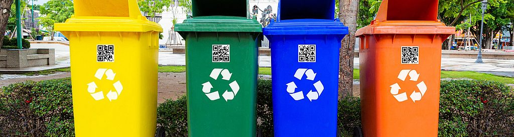
Are the trash bins in the park emptied? Or is it not yet necessary? What about the containers at the recycling center? And how is the refilling of dog waste bag stations organized? These are everyday questions for municipalities.
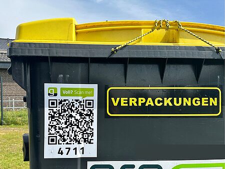
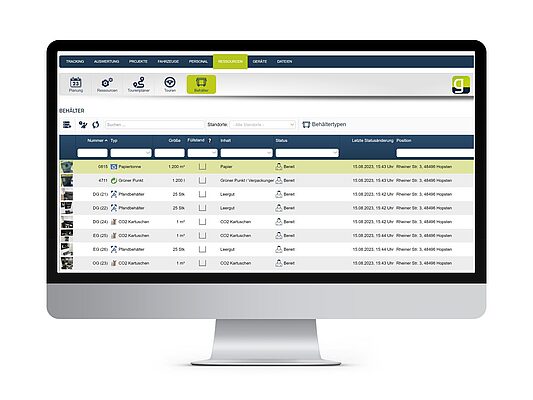
Municipalities benefit from smart fill level monitoring: thanks to real-time data via sensors or a reporting system using QR codes, the administration always knows which containers need to be emptied or refilled. No more guessing — clear data for clean cities.

We’ll show you how your municipality can master the path to digital waste management in 4 steps.

Applications of Digital Container Management


Public trash bins

Behälterverwaltung für öffentliche Mülleimer mit geoCapture zur effizienten Leerungsplanung

Public containers

[Translate to English:] Müllcontainter

Dog waste ­bag stations


Damage­reports

Städtische Straßenbeleuchtung bei Dämmerung mit leuchtender Laterne vor moderner Architektur

Any type of container

[Translate to English:] Streugutbehälter

STEP 1: Attach a sensor or QR code to the containers

The sensor is simply mounted on the inside of the lid of the desired container — no complex modifications or cables required. It is robust, weatherproof, and ready for immediate use. Once installed, it automatically measures the container’s fill level and transmits this data in real time.
Attaching a QR code to the container allows citizens to report when it needs to be emptied or refilled. This saves you unnecessary trips.

STEP 2: Automatic data collection via sensor

At regular intervals, the sensor transmits fill level data via the LoRaWAN network. This wireless network reliably transfers small amounts of data over long distances, ensuring that even remote locations are easily reached.

STEP 3: Display data in the porta

In the geoCapture portal, you can view all containers and their current status on a map. The fill levels are clearly visualized and can be accessed at any time, so you immediately know where action is needed.
Additionally, the data can be used for route planning or container management. Only the containers that need to be emptied or refilled are included in the routes, helping to avoid unnecessary trips and work steps.

STEP 4: Plan and analyze routes

Based on real-time data, the system automatically plans the most efficient routes. Only full containers are scheduled for emptying — eliminating unnecessary trips and work steps. This saves time, fuel, and enables data-driven waste management.

More about route planning with geoCapture

Your Benefits with geoCapture Container Management

QR code on the container

Citizen participation: Request bin emptying or replacement without downloading an app
(scan the code without an app) 

Easy for Citizens

Scan the QR code and send a
request without signing up.

Real-time data thanks to durable sensor technology

Know which containers need to be emptied or refilled at any time thanks to modern data transmission via LoRaWAN.

Route Planning

Optimal routes for container emptying,
standard tours, and on-demand orders

Fill Level

Automatic level notifications via sensors,
Option to notify when emptying is required via QR code 

100 % Cloud

All information about the
containers in one central location

Driver App

Real-time communication and task
management for field teams

Statistics

Data analysis and report generation

User-Friendly

easy to understand and intuitively usable

How does the sensor work with LoRaWAN?

The geoCapture sensors use state-of-the-art radar and laser technology. They measure the fill level precisely – without any visual contact or manual checks. The data is transmitted securely via LoRaWAN, an energy-saving radio network with a long range. This means that containers can be monitored even in remote locations – reliably, energy-efficiently and independently of mobile networks.

Advantages of LoRaWAN technology:

  • Long range – ideal for large municipalities

  • Very low energy consumption – battery life lasting years

  • Secure, stable data transmission

  • No Wi-Fi or mobile network required

5 Facts on why you should drive digitalization with geoCapture.

  • Fact 1: You counteract the skilled labor shortage.

    geoCapture's container management addresses the skilled labor shortage by making waste processes more efficient. By monitoring the fill levels of waste containers, emptying processes are optimized, and collection routes can be planned more precisely. The software's intuitive user interface allows for easy integration into the daily work of employees, minimizing training times. This contributes to effectively utilizing existing skilled workers and optimizing waste management in the municipality.

  • Fact 2: You ensure efficient resource utilization.

    With geoCapture's container management, municipalities can utilize their resources more efficiently. Monitoring the fill level enables precise planning of collection routes, eliminating unnecessary trips. This not only benefits the environment but also reduces costs. This smart resource planning helps municipalities operate more economically and sustainably.

  • Fact 3: You make communication transparent for citizens.

    The container management by geoCapture contributes to transparent communication between the municipal administration and the citizens. Citizens can scan the QR code on the container, allowing them to request an emptying or container exchange without the need for an app download. Reporting the discovery of a container is also possible. This straightforward communication with the municipality builds trust and enhances citizen satisfaction.

  • Fact 4: You save time and costs through automation.

    The automation of waste processes using container management leads to significant time and cost savings. Manual monitoring and planning are a thing of the past. The software displays the current fill levels of the containers and generates optimal route suggestions. This allows for faster and more efficient waste disposal. The saved time and reduced operating costs can be invested in other important projects.


  • Fact 5: You make data-driven decisions.

    geoCapture provides extensive data on waste management, serving as a foundation for informed decision-making. By analyzing this data, municipalities can identify trends, optimize emptying processes, and develop long-term strategies. These data-driven insights help municipalities continuously enhance their waste management and implement sustainable measures.

Request a quote now

Take the first step towards a digital municipality today.

Request a quote