Kartenskizzen einfach mit miamapo erstellen
miamapo

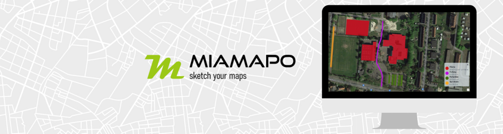
miamapo: Map editor in geoCapture

Easy creation of map sketches and site plans

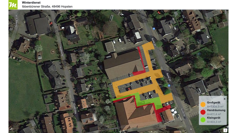
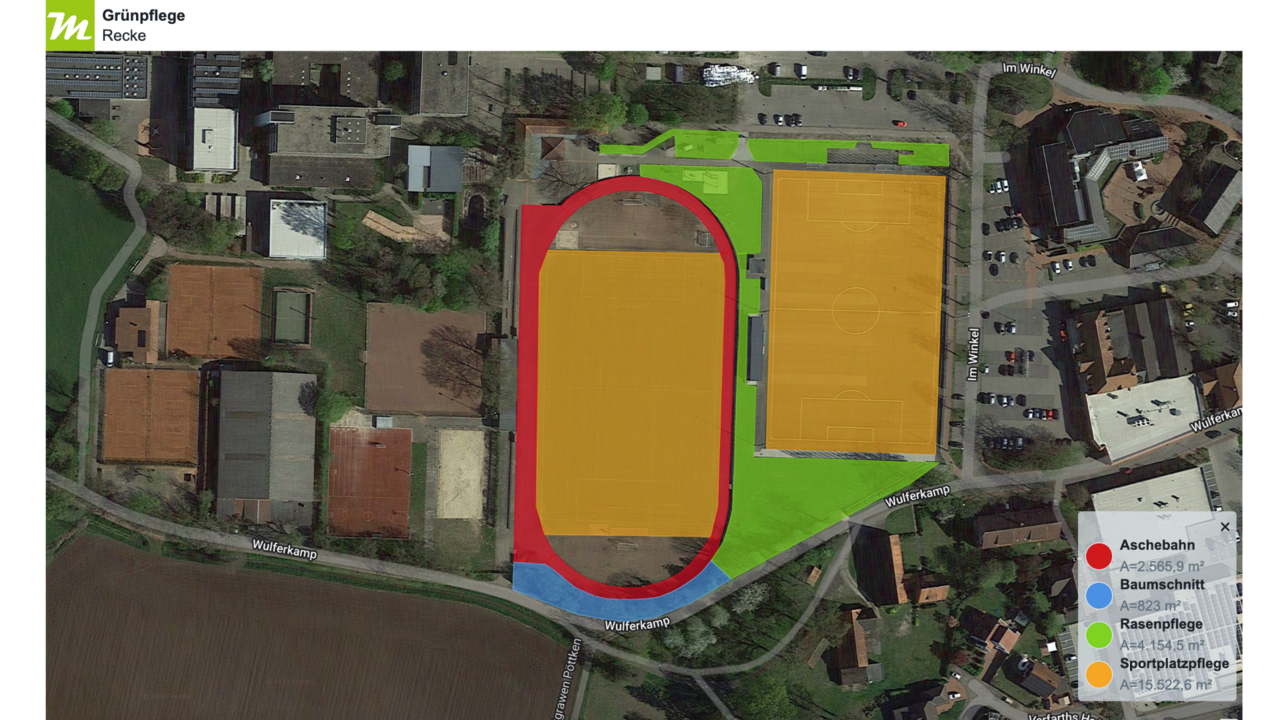
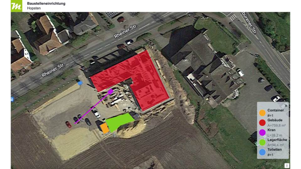
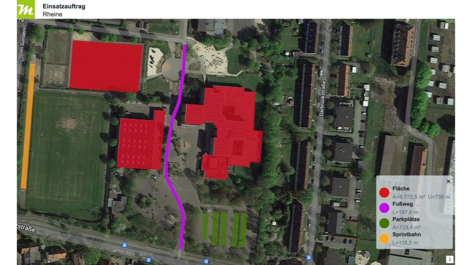
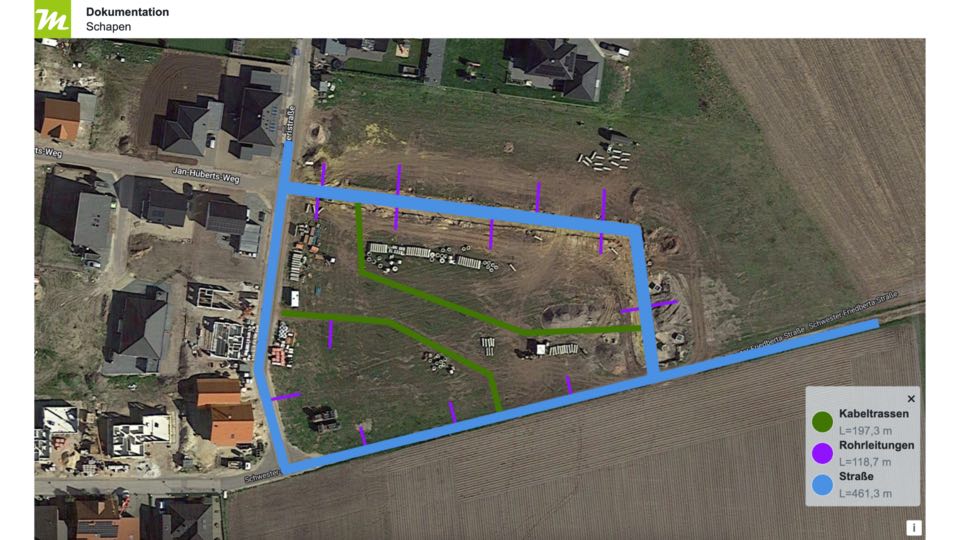
Creating site plans or sketches by screenshot and graphics program are a thing of the past.
With the simple and comfortable map editor of miamapo you can create sketches based on
Google Maps directly in geoCapture in no time. To work together on the maps, they can be
shared via link with customers, business partners or colleagues. This way, everyone has
always access to the current version of the map.

From quotation to order processing, work can be done on the same map. As a result, all employees always have the same status of the map and there are no misunderstandings. This leads to increased transparency and efficiency in the workflow.

Increased efficiency through miamapo in geoCapture


Facilitation of quotation and invoicing through automatic transfer of area and length calculations to ERP system - mass determination
Productive map processing through miamapo compared to graphics programs - Time saving
Effective collaboration with colleagues, customers or business partners through link sharing - Map sharing
Additional availability of maps through use of the geoCapture app - Flexibility
Ensuring correct maintenance areas through access to current maps - Avoiding errors
Possibility to add maps directly as attachments to orders and projects - Documentation

Your advantages with the miamapo map editor

With the powerful editor of miamapo you create maps in no time directly in geoCapture. You simply add the map sketch to your project or job or import existing miamapo maps without leaving the geoCapture portal. The application is designed to be user-friendly. The project position is transferred directly to the miamapo map. Once the map sketch is created, it can be easily attached to the project or job.

You can access your miamapo maps anywhere and at any time via mobile App. In addition to the sketch, colleagues on site have all relevant information on areas, dimensions or distances at their fingertips. This leads to increased efficiency and transparency in the team.

  • maximum ease of use
  • Efficient workflows
  • Improved collaboration

geoCapture with miamapo saves time, avoids errors and facilitates collaboration.

Register now!

Start now with intuitive map creation with miamapo.

 Register now

What our customers say

"We use miamapo daily and are impressed by the ease of use. We generate a map, create a quotation from the determined masses and provide the maps to our employees so that they know exactly which object needs to be maintained. miamapo really makes our work a lot easier!"

John-Paul Müller, Dispatcher Quathamer GmbH

Many functions for map creation with miamapo

Many functions and tools are available for map creation with miamapo.

Map-Editor

The user-friendly editor is the central tool of miamapo. In the editor you create map sketches on street maps or satellite maps.

Drawing tools

The editor offers many different tools to create your map. Among them rectangles, polygons, lines, polylines or circles. You can also add texts, fonts and graphics and photos to your map.

Mass determination

miamapo automatically determines masses, such as areas, perimeters, lengths or volumes. These data are so accurate that you can use these masses as a basis for quotations or invoices.

Import

You can easily use your own data in miamapo. Import symbols, building floor plans, photos or drone images into your map sketch.

Export

For your map sketches and site plans miamapo offers the possibility to export them as PDF or PNG.

Cloud

All map sketches are 100% stored in the cloud. So you have access to your maps and site plans from any device.

The areas of application for maps with miamapo are endless

Operation plans for winter service
(small and large equipment, hand clearing)

Application plans for green maintenance
(lawns, hedges, flower beds, paved areas)

Planning of construction site equipment
(cranes, building material storage, containers)

Work and operation orders
(map sketch as an attachment to the order)

Documentation
(cable routes, pipelines, laying plans)

All you need to know about miamapo

  • How do I use miamapo in geoCapture?

    To create a miamapo map, you do not have to switch or leave the application. Just stay logged into the geoCapture portal. 

    With miamapo's user-friendly editor, you can create your map sketch directly in the project or job in no time at all. The project position is transferred to the miamapo map - it really couldn't be easier! You can import an existing map into your order or the project.

  • Do I have to log in?

    Clear answer: No! You do not have to register again in another programme. Simply register with us and we will activate your access to miamapo. 

    You create a completely accessible miamapo map in geoCapture and can subsequently edit this sketch or share it with colleagues, customers or business partners.

  • Which functions does the map editor of miamapo offer?

    The miamapo editor offers numerous functions: drawing circles, rectangles or polygons, automatic mass determination and inserting texts or images.

    You can find a detailed overview of functions here.

  • Can I edit the map later?

    Yes!
    You can call up the miamapo map in the project or order at any time and edit it or continue working on it. 

    If you add changes to the map, everyone with the release link automatically also has the current version of the map.

  • What does miamapo cost?

    You can find an overview of miamapo's rates here.

  • Why no more Screenshot and Paint?

    Creating map sketches with Screenshot and Paint certainly works, but it brings many problems with it:

    • time consuming
    • not very comfortable
    • no updating of the map material
    • no sketch modification
    • no determination of areas, perimeters, lengths
    • sharing of maps only as file
    •  

    Better: Create map sketches with miamapo!

  • Can I share the maps with colleagues, business partners or customers?

    You can share your maps with colleagues, customers or business partners via a share link. 

    Everyone with the link always has the current version of the map. This way you can work together on the maps or make them available for viewing.

  • I don't know how to create a map. What now?

    Creating a map in geoCapture is very simple. Simply call up one of your projects and add a miamapo map under the "Documents" tab.

    We have created a video on how to do this. Here we explain exactly how to create a miamapo map in your geoCapture account.

Register now!

Convinced? Then create your map sketches and site plans now only with miamapo.

Register now