IDENTIFY AND AVOID DETOURS THROUGH GPS-LOCATION
Many companies know the problem: employees do not always choose the optimal route to the construction site or to the customer. Every day, companies lose a lot of time and money because drivers choose cumbersome and time-consuming detours. The causes are manifold: Ignorance, dawdling or convenience are the most common.
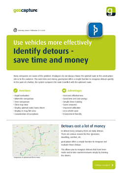
GeoCapture offers a simple function to recognize these detours quickly. At the touch of a button, the system compares the route travelled with the optimum route. Excessive deviations are evaluated at lightning speed - even over long periods of time. On a map you can see the comparison between the route driven and the optimum route. It couldn't be clearer!
You will be surprised at how many detours your company takes.
If you have the target kilometres and the actual kilometres driven displayed in the clear list view, you can see directly how many more kilometres have been driven and decide for yourself whether the detour is still within the limits.
This way you can draw the driver's attention to his mistakes and train him accordingly. Detours will be a thing of the past in the future. This will save your company a lot of time and money. And you also protect the environment.
A simple set of rules can be used to add exceptions so that intended detours (e.g. due to detours) are no longer criticised in the future.